

Expect a 3 a.m.-ish pickup, roughly 3 hours on the road to the trailhead at about 4,600 to 4,800 m, then a hike of around 4 km each way gaining roughly 400 m to reach the striped summit at 5,036 m (some trail markers list it closer to 5,200 m). The climb itself typically takes 2 to 3 hours up and 1.5 to 2 hours down, walked slowly because of the altitude, not the distance. You’ll be cold at the trailhead, short of breath within the first ten minutes of climbing, and standing in a crowd once you reach the top, since this has become one of the most visited single-day hikes near Cusco. None of that takes away from the view. This is the real shape of the day, not the marketing photos, so you know what you’re actually signing up for. For the full planning details, permits, and season-by-season advice, see our complete Rainbow Mountain guide.
The 3 a.m. pickup and the drive out
Most Rainbow Mountain day tours start with a pickup somewhere between 3:00 and 4:00 a.m., since the drive out and the hike itself both take real time, and operators want you at the trailhead before the worst of the midday crowd and the afternoon weather. Expect the bus to circulate through several hotels before leaving Cusco, so if you’re not the first pickup, budget extra time sitting in the vehicle before you’re actually moving.
The drive covers roughly 100 km southeast of Cusco through Urcos, Ccatca, and Ocongate toward the Cusipata region, on paved road for most of the distance, then unpaved for the final stretch closer to the trailhead. Total driving time runs about 3 hours, and much of it happens in the dark on the way out, so don’t expect scenery on this leg, most of the drive passes before sunrise.
Breakfast stop and what the road is like
Tours typically stop partway through the drive for breakfast at a roadside restaurant serving other Rainbow Mountain groups on the same schedule, coffee or tea, bread, eggs, and similar simple fare. This is also usually your last real bathroom stop with reliable facilities before the trailhead itself, so use it even if you don’t think you need to.
The road itself climbs steadily in altitude as you go, and by the time you’re approaching Cusipata and the unpaved final stretch, you’re already well above Cusco’s own 3,400 m, which matters more than people expect. If you haven’t spent time acclimatizing before this tour, the discomfort starts on the bus, not on the trail. For guidance on preparing your body before a day like this, see your first 48 hours in Cusco.
Weather along this route shifts by season more than by hour. During the dry season, April through October, mornings tend to be clear and cold with strong sun once the sky lightens. During the rainy season, November through March, the same drive can involve fog, rain, or even snow at the higher points of the road, and the trail itself becomes slipperier underfoot. Neither season cancels the tour outright, but rainy-season visitors should expect a real chance of reduced visibility at the summit, sometimes to the point where the colors are only partially visible through mist.
The trailhead: altitude, cold and first impressions
Stepping off the bus at the trailhead, roughly 4,600 to 4,800 m depending on the specific access point, is usually the first real jolt of the day. Temperatures at that hour commonly sit well below freezing, and the wind at this elevation cuts through layers faster than the actual temperature reading suggests. Bring more warm layers than you think you need, gloves and a hat matter here even if you didn’t pack them for Cusco itself.
The trailhead area is typically crowded with other tour groups arriving on a similar schedule, horses and horse handlers waiting for clients who’ve booked the ride option, and a registration or entrance fee point depending on the specific route. Take a few minutes here to layer up properly and use the bathroom facilities if available, since options thin out once you start climbing.
What surprises most first-time visitors isn’t the cold itself, it’s how quickly it changes once the sun clears the surrounding peaks. Standing at the trailhead before sunrise can mean layering up in gloves and a hat, then stripping down to a single warm layer forty minutes later once you’re moving and the sun is fully up. Pack layers you can add and remove easily rather than one heavy jacket, since you’ll likely need both extremes within the same morning.
The climb: how it actually feels at 5,000 m
The trail itself covers roughly 4 km from trailhead to summit, climbing around 400 m in that distance, numbers that would be unremarkable at sea level and feel entirely different above 4,600 m. Within the first ten minutes, most visitors notice their breathing working harder than the terrain seems to justify, this is altitude, not fitness, and it affects experienced hikers and first-timers alike if they haven’t acclimatized.
The path is a well-defined trail through alpine grassland and rocky terrain, not technical, but the pace that works is slow and steady rather than pushing hard and stopping to recover. Guides set a deliberately unhurried rhythm for exactly this reason. Toward the final stretch, the trail steepens into sandier switchbacks, the hardest section of the climb both physically and mentally, since the summit is visible but still requires sustained effort to reach. For a full breakdown of the trail itself, distances, and where the steep sections fall, see the Vinicunca trail step by step.
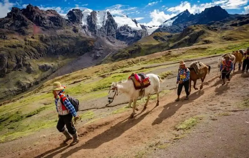
If walking at this altitude concerns you, horses are available for at least part of the ascent on the standard route. See going up by horse for what that option actually covers and where it drops you relative to the summit.
Headaches, mild nausea, and a heavier-than-usual heartbeat at rest are common at this altitude even among people who’ve spent several days acclimatizing in Cusco beforehand, since 5,000 m is meaningfully higher than anything most travelers encounter elsewhere on a Peru trip. These symptoms are normal at this elevation and typically pass once you’re back at lower altitude later in the day. Symptoms that don’t improve with rest, or that get noticeably worse rather than better, are worth mentioning to your guide immediately rather than pushing through quietly. Guides on organized tours are trained to recognize altitude symptoms that warrant turning back rather than continuing to the summit, and typically carry basic supplemental oxygen for exactly this situation.
The summit: crowds, wind and how long you stay
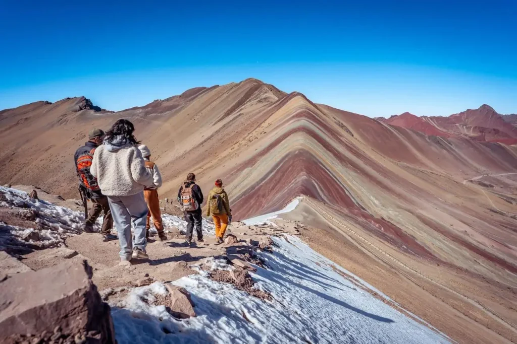
Reaching the striped slopes is the payoff, and on a clear day, the layered reds, golds, and greens are exactly as vivid as the photos suggest. What the photos don’t show is the crowd: this has become one of the most visited single-day excursions from Cusco, and the main viewpoint area gets genuinely busy, particularly mid-morning when multiple tour groups converge on a similar schedule.
Wind at the summit is typically strong and cold, even on a clear, sunny day, so the temptation to linger for photos competes directly with the discomfort of standing still at 5,000-plus meters in open wind. Most groups spend somewhere between 30 minutes and an hour at the top, enough time for photos and to actually take in the view, not a long stay given the conditions.
The colors themselves come from mineral deposits, iron, copper, and sulfur compounds among others, laid down in horizontal bands over millions of years and later tilted near-vertical by tectonic movement, then exposed as the glacier that once covered the slope retreated. This is a relatively recent phenomenon in terms of public visibility: the mountain was largely hidden under ice until roughly a decade ago, which is part of why it went from an obscure stop on longer Ausangate treks to one of the most visited single-day excursions near Cusco in a short span of years. Visibility of the full color range depends heavily on weather and light, an overcast day mutes the effect considerably compared to direct sun.
The way down and the drive back
The descent takes noticeably less time than the climb, typically 1.5 to 2 hours, and while it’s physically easier since you’re moving downhill, altitude fatigue from the climb often catches up with people on the way down rather than at the summit itself. Knees and ankles take more strain on the descent than most visitors expect, given the sandy, loose sections near the top.
Back at the trailhead, the drive to Cusco retraces the outbound route, this time in daylight, so you’ll actually see the landscape you passed through in the dark that morning. Lunch is typically included on the return leg, either at a stop along the road or back closer to Cusco depending on timing. Most groups arrive back in Cusco sometime in the early evening.
How you will feel that evening
Fatigue after Rainbow Mountain is different from ordinary hiking fatigue, it’s altitude fatigue layered on top of an unusually early start, and most visitors feel it more in the hours after the tour than during the hike itself. A heavy, slightly foggy tiredness, sore legs, and an early bedtime are typical, even for people who consider themselves reasonably fit.
This is a normal response to a long day spent largely above 4,600 m, not a sign that something went wrong. Staying hydrated throughout the day and eating properly at both stops helps meaningfully, but don’t plan anything demanding for that evening or the following morning. If you’re combining this excursion with other high-altitude activities during your trip, space them out rather than stacking back-to-back big days.
A few practical notes worth knowing before you sign up: bring more water than you think you’ll need, since dehydration compounds altitude fatigue significantly, and pack sun protection even on a cold morning, since UV exposure at 5,000 m is intense regardless of air temperature. Cash in small denominations is worth carrying for any entrance fees, optional extras, or tips along the way, since card payment isn’t reliably available at the trailhead or along the route. Motion sickness on the winding mountain roads is common enough that if you’re prone to it, medication before departure is worth considering, particularly for the return leg once fatigue has set in.
Honest expectations vs the photos you have seen
The photos you’ve seen online are real, the colors are genuinely that vivid on a clear day, but they’re almost always taken without the crowd in frame, cropped tightly around the vivid stripes rather than showing the full scene. In practice, you’ll be sharing the viewpoint with dozens of other visitors at the same time, and getting an unobstructed shot takes patience and a bit of luck with timing.
The other gap between expectation and reality is the physical toll. Marketing material tends to undersell the altitude and the cold, focusing entirely on the view at the end. The honest version: this is a genuinely demanding morning, cold at the start, breathless through the middle, and rewarding at the top, not an easy walk with a photogenic payoff. Travelers who go in expecting that difficulty tend to enjoy the day more than those expecting a casual stroll. If you want to compare this experience directly against the shorter, less crowded alternative nearby, see Vinicunca vs Palccoyo before booking either one.
Rainbow Mountain, hour by hour
- ~3:00-4:00 a.m. Pickup from your hotel in Cusco.
- ~4:00-6:30 a.m. Drive southeast toward Cusipata, mostly in darkness.
- ~6:30-7:00 a.m. Breakfast stop along the road.
- ~7:00-8:00 a.m. Continue driving to the trailhead, final stretch on unpaved road.
- ~8:00 a.m. Arrive at the trailhead, layer up, register or pay entrance fee if applicable.
- ~8:00-10:30 a.m. Climb to the summit, roughly 4 km and 400 m of gain, walked slowly.
- ~10:30-11:15 a.m. Time at the summit for photos and rest, cold and windy even in sun.
- ~11:15 a.m.-1:00 p.m. Descend back to the trailhead.
- ~1:00-2:00 p.m. Lunch stop on or near the return route.
- ~2:00-5:00 p.m. Drive back to Cusco.
- Early evening. Arrival back in Cusco.
If a full-day itinerary like this fits your trip, our 1-day Rainbow Mountain tour covers the logistics, transport, and guiding for exactly this schedule.
Frequently Asked Questions
How difficult is the Rainbow Mountain hike really? The trail itself is short and not technical, but the altitude, above 4,600 m at the trailhead and over 5,000 m at the summit, makes it feel far harder than the distance suggests. Acclimatization matters more than fitness level.
What time do Rainbow Mountain tours start? Most tours pick up in the early hours of the morning, typically between 3:00 and 4:00 a.m., since the drive and hike together take most of the day.
Is Rainbow Mountain crowded? Yes, particularly at the summit during mid-morning, when multiple tour groups from Cusco converge on a similar schedule. Photos taken without the crowd usually involve some patience and timing at the viewpoint.
Can I do Rainbow Mountain without much hiking experience? Yes, the trail itself doesn’t require technical skill, and horses are available for part of the ascent. What matters most is spending a few days acclimatizing to altitude in Cusco before attempting the hike.