
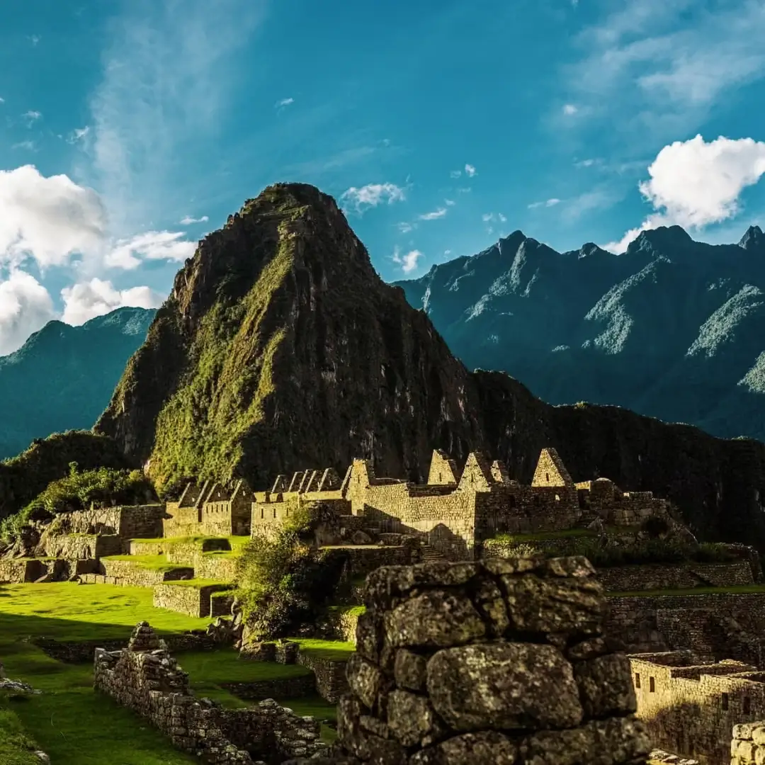
Follow in the footsteps of the last Inca resistance on this 16-day expedition through the remote Vilcabamba mountain range, from the spectacular ruins of Choquequirao — often called the “sister city of Machu Picchu” — to the historic sites of Vitcos and Espiritu Pampa, the true last capital of the Inca Empire. Crossing high Andean passes above 4,600 meters and descending into lush cloud forest and jungle, this trek covers some of the most historically significant and least-visited terrain in Peru.
Designed for seasoned hikers seeking a genuine wilderness challenge, this fully-supported expedition combines dramatic archaeology, remote Quechua villages, and diverse ecosystems — from arid highland passes to tropical valleys home to Peru’s national bird, the Gallito de las Rocas. It’s a rare opportunity to trace the final chapter of Inca history far from the crowds of the classic Inca Trail.
Overview
The 16-day Vilcabamba Trek is one of the most historically layered and physically demanding treks in Peru, tracing the actual retreat route of the last Inca rulers after the Spanish conquest. Unlike shorter Choquequirao treks that turn back after the ruins, this expedition continues deep into the Vilcabamba wilderness to reach Vitcos and Espiritu Pampa — sites most travelers never see.
Day-by-Day Expedition Summary
- Day 1: Cusco to Cachora via Limatambo – Drive from Cusco to explore the archaeological sites of Tarawasi and the carved Saywite Stone before camping in the mountain town of Cachora.
- Day 2: Playa Rosalina to Choquequirao (Campsite: Raqaypata) – Challenge yourself with a steep ascent through Apurímac Canyon to camp near the remote Inca citadel of Choquequirao.
- Day 3: Choquequirao to Rio Blanco – Tour Choquequirao, climb to Choquequirao Pass (3,300m / 10,827ft), and descend past Pinchiunuyuc terrace ruins to camp by Rio Blanco (1,800m).
- Day 4: Rio Blanco to Mina Victoria – Undertake a steep climb up Apurímac Canyon to camp near the historic colonial-era Victoria Mine (~4,000m / 13,123ft).
- Day 5: Mina Victoria to Yanama Valley – Ascend Victoria Pass for views of Salkantay and Humantay peaks, descending past high-altitude farms to camp in Yanama Valley (3,400m).
- Day 6: Yanama to Kelkamachay – Cross the high Choquetakarpo Pass (4,600m / 15,091ft), transitioning from lush vegetation to mountain tundra before descending to camp at Kelkamachay.
- Day 7: Kelkamachay to Kollpaq – Hike through the Kalkamachay Valley alongside historical sections of the Vilcabamba Inca Trail with views of Choquetacarpo Mountain.
- Day 8: Kollpaq to Huancacalle (Wankakalli) – Descend through inter-Andean valleys to Huancacalle, establishing base camp at the historical gateway of the Vilcabamba trailhead.
- Day 9: Huancacalle to Vitcos & Ñusta Hisp'anan – Explore the archaeological sites of Vitcos and Ñusta Hisp'anan (Yurac Rumi) with sweeping views over the Chaullay Valley.
- Day 10: Huancacalle to Qollpaq'asa via Rosapata – Hike to the summit ruins of Rosapata for views of Pucyura's snow-capped peak before continuing to camp at Qollpaq'asa.
- Day 11: Qollpaq'asa to Ututo – Trek past the Andean village of Pampaconas into the remote Maukachaka region, ending with riverside camping and fishing in Ututo.
- Day 12: Ututo to Vista Alegre – Begin descending into the temperate cloud forest along the Pampaconas River to camp at Vista Alegre.
- Day 13: Vista Alegre to Concevidayoc – Hike through the warm Vilcabamba Valley up to Cruz Q'asa pass to spot Peru's national bird (Cock of the Rock) before reaching Concevidayoc.
- Day 14: Concevidayoc to Espiritu Pampa – Follow the Pampaconas River to Espiritu Pampa, the last capital of the Incas, to explore ancient ruins and the historic Rumichaca stone bridge.
- Day 15: Espiritu Pampa to Chiwankiri – Complete the final leg of the trek through tropical, humid jungle terrain to spend your last camping night in Chiwankiri.
- Day 16: Chiwankiri to Cusco via Kiteni & Lares Valley – Journey back to Cusco via private transport, driving through Kiteni, the high-altitude Lares Valley, Amparaes, and Calca.
Itinerary
Day 1: Cusco – Limatambo – Cachora
At 8:00 a.m., we will pick you up from your hotel in Cusco to start our adventure. Our first destination will be Limatambo, where we will visit Tarawasi, an important Inca archaeological site characterized by its finely crafted stone walls and ceremonial platform, possibly used for agricultural and religious rituals.
Continuing our journey, we will pass through the picturesque towns of Conoc and Crahuasi until we reach Saywite, where we will explore the enigmatic Saywite Ceremonial Stone. This enormous carved rock, featuring more than 200 relief figures, is considered a three-dimensional map of Inca hydraulic systems and an important center for water worship.
From Saywite, we will begin our descent to Cachora, a small Andean town surrounded by breathtaking mountain landscapes. Here, we will set up our campsite for the night, preparing for the start of our hike the next day.
Meals:Lunch / Dinner
Day 2: Playa Rosalina – Choquequirao
Day 2 is an arduous ascent as we climb from 1,500m (4,921ft) up to Choquequirao, which is at 3,000m (9,843ft). The journey will be challenging but rewarding, as we traverse breathtaking landscapes and witness the diverse ecosystems of the Andean highlands.
Along the way, we’ll pass through the towns of Santa Rosa and Marampata, where we can rest and take in the stunning views of the Apurímac canyon. As we gain altitude, the scenery transforms from arid slopes to lush cloud forest, home to a variety of flora and fauna, including orchids and the majestic Andean condor.
In the afternoon, we will arrive at our campsite in Raqaypata, strategically located near the impressive ruins of Choquequirao. After settling in, we will have the opportunity to explore part of this remote Inca citadel, often referred to as the “sister city” of Machu Picchu. With fewer visitors, Choquequirao offers a unique and serene atmosphere, allowing us to immerse ourselves in its history and significance.
Meals:Breakfast / Lunch / Dinner
Day 3: Choquequirao – Pinchiunuyuc – Rio Blanco
After a guided tour of the Choquequirao archaeological complex, we’ll begin our hike to the Choquequirao Pass at 3,300m / 10,827ft. The pass offers stunning panoramic views of the surrounding valleys and mountains, making this part of the journey both challenging and rewarding.
From the pass, we’ll begin our descent to Pinchiunuyuc, a beautiful spot where we’ll stop for lunch and take in the tranquility of the Andean landscape. Afterward, we’ll continue our descent toward Rio Banco, located at 1,800m (5,906ft). This section of the hike will take us through lush forests and alongside streams, offering a complete contrast to the high-altitude landscapes we’ve encountered so far.
We’ll set up camp along the river for the evening, where we can relax and enjoy the sounds of nature, preparing for another day of adventure.
Meals:Breakfast / Lunch / Dinner
Day 4: Rio Blanco – Mina Victoria
Day 4 is a difficult ascent to approximately 4,000m (13,123ft), where we will find the Victoria Mine near San Juan Pass. This mine was abandoned shortly after the colonial period and offers a fascinating glimpse into the past. As we reach this high point, we will be rewarded with sweeping views of the surrounding landscape, including the impressive Apurimac Canyon – one of Peru’s many geographic marvels.
The ascent will be physically demanding, but the historical significance of the mine and the breathtaking vistas make the effort worthwhile. After visiting the mine, we’ll take a moment to enjoy the views and rest before continuing our journey.
Meals:Breakfast / Lunch / Dinner
Day 5: Mina Victoria – Yanama
On day 5, we will ascend to Victoria Pass, where we will be treated to awe-inspiring views of the snowy summits of Salkantay, Corihuaynachina, and Humantay mountains. The grandeur of these peaks will make the challenging climb worthwhile, offering a true sense of being immersed in the heart of the Andes.
As we continue our hike, we will pass through patches of agricultural land, where local farmers cultivate crops in the high-altitude environment. These landscapes offer a glimpse into the resilience and ingenuity of the people living in this remote region.
Our destination for the day will be the picturesque valley of Yanama, located at 3,400m (11,155ft). We will set up camp near the local high school, enjoying the serene atmosphere of the valley as we rest and prepare for the next leg of our journey.
Meals:Breakfast / Lunch / Dinner
Day 6: Yanama – Choquetakarpo – Kelkamachay
Having camped for the night in the village of Yanama, we’ll begin our trek again with an ascent to the Choquetakarpo Pass, located at 4,600m (15,091ft). The trail starts off blanketed with lush vegetation, gradually transforming into mountain tundra as we gain elevation. This change in landscape offers a unique opportunity to witness the diversity of ecosystems found in the high Andes.
The ascent to the pass is challenging, but the panoramic views from the top will make the effort worthwhile. From Choquetakarpo, we will take in breathtaking vistas of the surrounding mountains and valleys. Afterward, we will begin our descent toward Kelkamachay, where we will set up camp for the evening, ready to rest and enjoy the tranquility of the area.
Meals:Breakfast / Lunch / Dinner
Day 7: Kelkamachay – Kollpaq
On Day 7, we will hike along the Kalkamachay Valley, where we will be treated to spectacular views of the Vilcabamba mountain range and the imposing peak of Choquetacarpo Mountain, which will stand directly in front of us. The beauty of this valley is unparalleled, with dramatic landscapes at every turn.
As we walk along the path, we’ll also have the opportunity to view sections of the Vilcabamba Trail, a historic route that once connected the Inca Empire. Our trek will take us to an altitude between 3,500m–3,800m (11,483–12,467ft), where the views become even more breathtaking as we gain elevation.
We will arrive in Kollpaq in the early evening and set up camp, ready to rest after a day of incredible scenery and exploration.
Meals:Breakfast / Lunch / Dinner
Day 8: Kollpaq – Wankakalli
After a nourishing breakfast, Day 8 begins with beautiful vistas of inter-Andean valleys. We’ll descend to Huancacalle, an important location in this region because it represents the starting point of the Vilcabamba trailhead. This historical site was once a key part of the Inca trail network.
In our case, Huancacalle will also serve as the base camp for our return trip to the Vilcabamba Valley. It offers a peaceful setting for the evening as we prepare for the final leg of our journey.
Meals:Breakfast / Lunch / Dinner
Day 9: Wankakalli – Vitcos – Ñusta Hisp´Anan – Qollpaq’asa
On Day 9, we’ll visit Vitcos, a site located on the upper portion of Huancacalle. From here, we will be able to view the entire Chaullay Valley and the Vilcabamba River below, offering stunning panoramic views of the surrounding landscape.
After another hour of trekking, we’ll arrive at Ñustahispanan, an important archaeological site. We will enjoy a guided tour of the ruins, where you’ll learn about the fascinating history and significance of this place. Afterward, we will return to our base camp to rest and reflect on the day’s exploration.
Meals:Breakfast / Lunch / Dinner
Day 10: Wankakalli – Qollpaq’asa
On Day 10, we’ll trek to the archaeological center at the summit of Rosapata, where we will be able to view Pucyura’s snowy peak along the adjacent sierra. The views from the summit are truly breathtaking, offering a unique perspective of the surrounding mountains and valleys.
Later, we’ll visit Nusta hisp’anan (Yurac Rumi), a historical site with significant cultural and archaeological value. Along the way, we will enjoy the beautiful countryside, immersed in the serenity of the Andean landscape.
In the evening, we’ll make our way to Qollpaq’sa, where we’ll set up camp for the night, reflecting on the incredible sights and experiences of the day.
Meals:Breakfast / Lunch / Dinner
Day 11: Qollpaq’asa – Ututo
We’ll begin Day 11 by making our way to the Maukachaka region, a beautiful and remote area known for its natural beauty. Along the way, we’ll pass through Pampaconas, a charming village where we can take a moment to appreciate the local culture and surroundings.
Afterward, we’ll begin our descent to Ututo, where we’ll set up camp for the night. In the evening, we’ll take the opportunity to do some fishing in the nearby river, enjoying the peaceful environment and the chance to relax.
Meals:Breakfast / Lunch / Dinner
Day 12: Ututo – Vista Alegre
Day 12 marks the beginning of our return descent. As we descend, we will start to see the lush vegetation of the temperate jungle, with the Pampaconas River winding below us. The change in scenery from the highlands to the jungle offers a beautiful contrast and a chance to experience the diverse ecosystems of the region.
We’ll enjoy lunch on the shores of the Pampaconas River, surrounded by the natural beauty of the area. After a short rest, we’ll continue our trek to Vista Alegre, a peaceful spot where we’ll set up camp for the evening and rest after a rewarding day of exploration.
Meals:Breakfast / Lunch / Dinner
Day 13: Vista Alegre – Concevidayoc
After breakfast on Day 13, we’ll trek into the Vilcabamba Valley, where we will be greeted by the warmth of the valley’s climate. In the heat, we’ll make the ascent to Cruz Q’asa, a popular site that offers panoramic views and a chance to appreciate the valley’s abundant flora and fauna. Along the way, we may even spot the vibrant Gallitos de las Rocas (Cocks of the Rock), a striking bird native to this region.
As we continue hiking across the valley, we’ll make our way to Tunkimayu, another scenic location, before continuing on to Concebidayoc, our destination for the day.
Meals:Breakfast / Lunch / Dinner
Day 14: Concebidayoc – Espiritu Pampa
On Day 14, we’ll journey east towards the mighty Pampaconas River, whose rushing waters will lead us to the legendary site of Espiritu Pampa. This area, known for its breathtaking landscapes, sits at the base of the Espiritu Pampas mountain range, forming a natural triangle with the Pampaconas and Chomtabamba rivers.
From this vantage point, we’ll take in panoramic views of the Andes sierra and the remarkable Rumichaca, an ancient stone bridge dating back to the Inca period. Believed to have been a vital crossing point for Inca caravans, Rumichaca stands as a testament to the engineering prowess of this great civilization.
During our guided exploration, we’ll uncover the fascinating history of the site and its significance in the region. As the day winds down, we’ll set up camp near Espiritu Pampa, immersing ourselves in the tranquility of the surrounding wilderness.
Meals:Breakfast / Lunch / Dinner
Day 15: Espiritu Pampa – Chiwankiri
Day 15 is our last day of hiking. As we move along the Valley of Espiritu Pampa, we will enter a tropical and humid climate, marking a stark contrast from the high-altitude landscapes we’ve traversed in previous days. The lush vegetation and warm air will signal our transition into the jungle zone.
Our journey will bring us to Chiwankiri, the site of our last evening in the outdoors, where we will enjoy a well-deserved rest surrounded by the serenity of nature.
Meals:Breakfast / Lunch / Dinner
Day 16: Chiwankiri – Kiteni – Cusco
On Day 16, we’ll begin our return journey by private van, traveling through breathtaking Andean landscapes. Our route will take us through the city of Kiteni, a gateway to the Amazonian lowlands, before ascending into the stunning Lares Valley, known for its picturesque scenery and rich cultural heritage.
We’ll continue our drive through Amparaes and Calca, two charming towns nestled in the Sacred Valley. Finally, we’ll make the final ascent to the historic city of Cusco, bringing our unforgettable adventure through the Vilcabamba region to a close.
Meals: Breakfast / Lunch / Dinner
Includes
- briefing.
- Private Transportation in and out: Cusco – Limatambo / Chiwankiri – Cusco.
- Private Guide: 2 guides for groups over 12 people.
- Cook: In charge of meal preparation.
- Horsemen and horses: Carry tents, cooking equipment and also carry backpacks, sleeping bags and mattresses (Max. 15 kilos/ 33 lbs per person).
- Emergency Horse: Just in case someone needs help.
- Meals: as mentioned in the itinerary
- Equipment: tents ( 2 people in each 3-person-capacity ), Therm-a-rest sleeping pad, dinner tent, special biodegradable bathroom tent, kitchen tent, shower tent, tables and chairs, table settings, first aid kit, including emergency oxygen bottle.
What’s Not included
- International and domestic flights and taxes.
- Travel Insurance (compulsory)
- Gratitudes.
Packing List
To ensure you are fully prepared for this adventure, please pack the following items:
Clothing:
- Lightweight, moisture-wicking clothing for hiking
- Warm layers (fleece or down jacket for cold nights)
- Waterproof jacket and pants
- Sun protection clothing (wide-brimmed hat, UV-protective clothes)
- Hiking boots (sturdy, broken-in, waterproof)
- Sandals or camp shoes for after hiking
- Comfortable socks (both regular and wool for warmth)
- Gloves and hat for cold temperatures (especially at higher altitudes)
Personal Gear:
- Small daypack (for carrying essentials during the hike)
- Sleeping bag (rated for cold temperatures, ideally down or synthetic for warmth)
- Sleeping mat (inflatable or foam for comfort)
- Headlamp with extra batteries
- Camera and extra memory cards
- Water bottle or hydration system (at least 2 liters capacity)
- Personal snacks (energy bars, trail mix)
- Personal hygiene items (toothbrush, toothpaste, wet wipes, biodegradable soap)
Health and Safety:
- First aid kit (with blister treatment, pain relievers, band-aids, etc.)
- Personal medications (if needed)
- Altitude sickness medication (consult your doctor before the trek)
- Sunscreen (SPF 30 or higher) and lip balm with SPF
- Insect repellent (preferably DEET-free)
- Water purification tablets or water filter
Optional Items:
- Binoculars for bird watching
- Lightweight trekking poles
- Personal entertainment (books, journal, etc.)
- Camera tripod for landscape photography
Nota: Please keep in mind that all personal belongings should fit into a small duffel bag or backpack, as porters and pack animals will carry your gear. Limit your pack to essential items only to ensure comfort during the trek.
Location for: 16 Days Discovering Last Capital of the Incas
Travel Information
- Transport: Private van for return from Chiwankiri to Cusco.
- Difficulty: Challenging – For experienced hikers due to high altitudes and long days of trekking.
- Altitude: From 1,500m (4,921ft) to 4,600m (15,091ft).
- Duration: 16 days / 15 nights.
- Best Time: April to October, the dry season.
- Accommodation: Camping with meals provided.
Difficulty Level and Who This Trek Is For
Rated challenging, this trek is designed for experienced hikers comfortable with long trekking days, high-altitude passes, and variable terrain; it is not recommended as a first multi-day trek in Peru.
Altitude Range and Acclimatization
The trek spans from 1,500m to 4,600m, with the Choquetakarpo Pass on Day 6 as the highest point; acclimatizing in Cusco for at least 2-3 days before departure is strongly recommended given the altitude swings.
Best Season to Trek
The dry season, April to October, offers the most stable trail conditions; outside this window, sections through the cloud forest and Vilcabamba Valley can become significantly more difficult due to rain and mud.
Fully Supported Camping Logistics
Horses and horsemen carry all camping equipment and personal items (up to 15kg per person), with a dedicated cook, dining tent, shower tent, and biodegradable bathroom tent provided throughout the 15 nights of camping.
Emergency Preparedness
A first aid kit including emergency oxygen is carried by the guide team, an important safety measure given the trek's combination of high-altitude passes and remote, hard-to-access terrain.
Return Transport from Chiwankiri
The final day involves a private van transfer from Chiwankiri back to Cusco, passing through Kiteni and the Lares Valley — a scenic but long drive that should be factored into end-of-trip planning.
Wildlife and Ecosystem Diversity
The route crosses high Andean tundra, cloud forest, and lowland jungle, offering the chance to spot the Gallito de las Rocas (Peru's national bird) as well as Andean condors near Choquequirao.
What's Not Included
International and domestic flights, mandatory travel insurance, and gratuities for guides, cooks, and horsemen are not included in the base tour price.
Physical Preparation Recommendations
Given the trek's long daily distances and significant elevation changes, previous multi-day trekking experience and a solid level of cardiovascular fitness are advised before attempting this route.
Group Size and Guide Ratio
A second guide is provided for groups larger than 12 people, ensuring adequate support and safety supervision across the trek's more remote and technically challenging sections.
Frecuendly asked questions
This trek is rated challenging, involving high-altitude passes up to 4,600m, long daily trekking distances, and varied terrain from cold highlands to humid jungle; it’s best suited for experienced hikers with prior multi-day trekking experience, rather than first-time trekkers.
While the standard route turns back after visiting Choquequirao, this 16-day expedition continues deep into the Vilcabamba wilderness to reach Vitcos, Ñustahispanan, and Espiritu Pampa — the true historical “Last Capital of the Incas” — covering significantly more remote and historically rich terrain.
Espiritu Pampa is the site now identified as Vilcabamba, the final refuge of the Inca rulers after their retreat from Spanish forces; long overlooked, it was later confirmed as the true “Last Capital of the Incas,” reshaping historical understanding of the empire’s final chapter.
The dry season, from April to October, is recommended for the most stable trail conditions; outside this window, the cloud forest and valley sections can become considerably more difficult due to rain.
The trek is fully supported with horses and horsemen carrying camping equipment and personal items (up to 15kg per person); trekkers only need to carry a small daypack with personal essentials during the day.
The route spans from 1,500m to 4,600m, descending through cold high-altitude passes into cloud forest, and eventually tropical jungle near Espiritu Pampa — one of the widest elevation ranges of any trek offered in the region.
Yes, given the altitude reaching 4,600m, there is a risk of altitude sickness; guides are trained to recognize and manage altitude-related issues, and prior acclimatization in Cusco along with proper hydration is strongly recommended.
Trekkers may spot Andean condors near Choquequirao and the Gallito de las Rocas (Cock of the Rock), Peru’s national bird, in the cloud forest and jungle sections of the Vilcabamba Valley.
The trek concludes with a private van transfer from Chiwankiri, passing through Kiteni and the scenic Lares Valley before arriving back in Cusco — a journey that forms part of Day 16’s itinerary.
Yes, significantly. Because it extends far beyond the point where most trekkers turn back, the Vilcabamba route to Vitcos and Espiritu Pampa remains one of the least-visited historical treks in Peru, offering a genuinely remote experience.